
Shoreline Management Plans (SMPs)
Short (0-20 years), medium (20-50 years) and long term (50-100 years) planning for flood and coastal risk management.
Shoreline Management Plans (SMPs) are high level, non-statutory policy document for coastal defence management planning, and are internationally considered a model of strategic planning at the coast.
Together they set out the strategic 100-year direction of travel for coastal management for Policy Units covering the entire coast, taking climate change into consideration, and based upon agreed objectives subject to high level economic and environmental assessments. The particulars of delivery of the agreed management approaches (Hold the Line, No Active Intervention, Managed Re-alignment or Advance the Line) are left to more focused Coastal Strategies and scheme design.
Coastal groups such as the Southern Coastal Group and SCOPAC provide a forum for discussion and co-operation and play an important role in the development of Shoreline Management Plans for their area.
There are five Shoreline Management Plans within the SCOPAC region – each of the hotspots below will link you to the appropriate plan at SMP Explorer, the Environment Agency’s online portal:
SCOPAC region SMPs
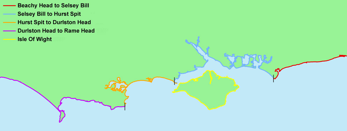
Durlston Head to Rame Head SMP16
Hurst Spit to Durlston Head SMP15
Selsey Bill to Hurst Spit SMP13
Isle of Wight SMP14
Beachy Head to Selsey Bill SMP12
Background
In 1994 the Coastal Groups and local authorities of England & Wales were encouraged by Government to adopt the concept of Shoreline Management Plans, with a view to providing a more strategic and sustainable approach to coastal defence. The first SMPs (SMP1) were completed by 2000.
Twenty second-generation SMPs (SMP2) were developed between 2006 and 2012 in England/cross border with Wales. They were developed inclusively and thoroughly by Coastal Groups, government bodies and other stakeholders, are approved by local councils, and finally signed off by the Environment Agency under its Strategic Overview for coastal flood and erosion risk management.
- an ‘SMP ‘Refresh’ [more below] commenced in 2019
SMP Policy Units:
SMPs divide the 6,000 mile shoreline of England & Wales into a series of cells and sub cells defined by coastal type and processes such as the movement of beach and seabed sediment (sand, shingle, etc) within and between them.
Following broad-brush assessments of the coastal flooding and erosion risks, and taking account of existing defences, people and the developed, historic and natural environments, and adjacent coastal areas, SMPs identify one of four shoreline management policies for sections of coastline (or Policy Units) within a sub-cell.
SMP management policy options:
- Hold the Line – maintaining the existing line of defence as it is or changing the standard of protection;
- No Active Intervention (do nothing) means that no investment will be made in coastal defences or other operations other than for safety purposes;
- Managed Realignment – allowing the shoreline to retreat or advance in a controlled or managed way, either because that is the best approach for a particular stretch of coast, or because the benefits of protection are clearly out of scale with the financial costs;
- Advance the Line – involves the building of new defences on the seaward side of existing defences.
The chosen policy must be technically feasible, environmentally acceptable and economically sustainable.
A shoreline management policy is applied per Policy Unit for the short (0-20 years), medium (20-50 years) and long term (50-100 years). Current coastal management objectives are often widely accepted and embedded in local planning policy; any future changes in management and policy need time to be implemented and are often, therefore, set in the later epochs (20-50 and 50-100 years).
Within these short, medium and long term timeframes the SMPs will also include an action plan that prioritises what work is needed to manage coastal processes into the future. This in turn will form the basis for deciding and, subject to available funding, putting in place specific flood and erosion risk management schemes, coastal erosion monitoring and further research on how to best adapt to change.
Consequently the SMPs provide a ‘route map’ assisting local authorities to formulate planning strategies and control future development of the shoreline. In addition, the final plans aid government to determine future national funding requirements for flood and coastal erosion risk management.
SMP Refresh 2019/20
According to a recent SMP review (Environment Agency, 2017) nearly a third of management policies contained within them require attention, of which about half may be undeliverable as they stand. SMPs require maintenance to be useful, but maintenance activity and effort across the SMPs has been variable.
An ‘SMP Refresh’ commenced in 2019, using a series of review and development activities to make sure the Plans are up to date, reliable and visible, and ensure onward maintenance is easier. The SMP Refresh will ensure SMPs are and remain ‘living’ documents.”
Within the same 2019/20 time frame, Coastal Partners (formerly the Eastern Solent Coastal Partnership) coordinated an update of the SCG and SCOPAC regional SMP Action Plans:
Southern Coastal Group SMP Action Plan Updates
PDF (2Mb) / Coastal Partners Briefing Note, July 2020
Update of the SMP Action Plans in the SCOPAC and Southern Coastal Group (SCG) Region.
SMP Explorer launched January 2024
Shoreline Management Plan Explorer (SMP Explorer) is a new online digital and map based system that holds the details of shoreline management plans around the coast of England, making them easier to access and use. The tool was developed by the Environment Agency in partnership with coast protection authorities, working together through the seven Coastal Groups of England.
SMP Explorer enables coastal practitioners and local planners to more easily find the information they need. It will also improve the Environment Agency’s ability to monitor the risks of flooding and erosion around England’s coasts.
Content will regularly be added to keep SMP Explorer up to date, starting with the new National Coastal Erosion Risk Map (NCERM), launched January 2025, which provides the most up to date national picture of coastal erosion risk for England using data from coastalmonitoring.org.
While aimed at coastal practitioners, SMP Explorer is also available to the public, helping to promote an understanding of the risks of coastal flooding and erosion, alongside the management approaches and actions being taken along the coast.
SMP Explorer – Find a Shoreline Management Plan
NCERM – Check coastal erosion risk for an area in England
Further background information at gov.uk/guidance/shoreline-management-plans
SCOPAC region SMPs at SMP Explorer
South Downs
Beachy Head to Selsey Bill SMP12
Lead: Arun District Council
Coastal Group: South East
North Solent
Selsey Bill to Hurst Spit SMP13
Lead: New Forest District Council
Coastal Group: Southern
Isle of Wight
Isle of Wight SMP14
Lead: Isle of Wight Council
Coastal Group: Southern
Poole & Christchurch Bays
Hurst Spit to Durlston Head SMP15
Lead: BCP Council
Coastal Group: Southern
South Devon & Dorset
Durlston Head to Rame Head SMP16
Lead: Teinbridge District Council
Coastal Group: South West
